Ward Boundary Proposed Charter Amendment: An Explainer
You may have seen the announcement for a public hearing about a proposed charter amendment regarding ward boundaries. While the exact legal language to the amendments is not reproduced here, it is intended to correct some mistakes in the town charter’s language describing the ward boundaries. I’ve drawn on some maps of Cheverly to illustrate the mistakes and the proposed corrections. I’ve focused mainly on corrections affecting Ward 4: I may have omitted some corrections to other wards, but these are some of the bigger ones.
To summarize:
Skipped block. The ward boundary description for Ward 4 mistakenly skipped a block. In previous elections, however, voters in that block had been able to vote in Ward 4. (A map of Ward 4 that previously was on the town website had included that block.) The proposed amendment will reflect this existing practice, and ensure that the block is included in Ward 4’s boundary description.
Stray line. The boundary descriptions for Ward 4 and Ward 6 include an extraneous line that is located entirely within Ward 4 (it isn’t a boundary at all). The proposed amendment will remove this stray mark from the ward boundary descriptions.
“Avenue,” not “Place.” A section of the Ward 6 boundary description said “63rd Place” when it should have said “63rd Avenue.” The same boundary line is described correctly in the description of Ward 3’s boundary (where Ward 3 is adjacent to Ward 6).
“East,” not “West." Part of the Ward 5 boundary description said “west” where it should have said “east” — it was intending to follow along the edge of the Cheverly Station apartments, starting from 63rd Place and going toward Kilmer.
Here is a link to the section of the town charter that describes the ward boundaries (Article III. Wards).
(Addendum, 10/17/2021: The September 29, 2021 worksession in which the council discussed Ward Boundaries is available online.)
I’ll go over the errors bulleted above and their intended corrections.
Skipped block.
First, the skipped block. The map below illustrates.

Map of the northwestern portion of Cheverly, with “Block omitted by mistake” near the bottom, labeled in red. Ward 4 is labeled in green to the east side of the block (bottom right), Ward 2 in blue to the west, Ward 1 in orange to the north, and Ward 3 in yellow to the northeast.
The Ward 1 description states:
First Ward: All that area lying north and west of a line beginning at the northern boundary and Cheverly Avenue and running south along Cheverly Avenue until the point where Forest Road crosses Cheverly Avenue and, then west southwest along Forest Road to Greenleaf Road and then running northwest along Greenleaf Road to Tremont Avenue, then north on Tremont Avenue, to Inwood Street, then west on Inwood Street in a straight line until the line ends at the western boundary.
Emphasis added by me: the bold text follows the line in orange in the map above.
The Ward 2 description states:
Second Ward: All that area lying south and west of a line beginning at the intersection of the western boundary and the extended centerline of Inwood Street, running east to Tremont Avenue, then south on Tremont Avenue to Greenleaf Road, then southeast on Greenleaf Road until it joins Forest Road and then east on Forest Road to Belleview Avenue, then southeast along Belleview Avenue to Cheverly Avenue, then south on Cheverly Avenue to Euclid Street then west to Lake Avenue and south along Lake Avenue to Benton Road, then west on Benton Road to Valley Way and south on Valley Way, until the line ends at the southwestern boundary.
Again, emphasis added by me: the bold text follows the line in blue in the map above.
The Ward 3 description states:
Third Ward: All the area contained in a line beginning at the northern boundary and Cheverly Avenue and running south on Cheverly Avenue to where Forest Road crosses Cheverly Avenue, then east on Forest Road to 63rd Avenue to its intersection with 63rd Place, then north on 63rd Place to Inwood Street, then northwest on Inwood Street to 63rd Avenue, then north-northwest on 63rd Avenue until it changes its name to 62nd Place, then along 62nd Place until the northern boundary, and then west along the northern boundary to Cheverly Avenue.
The bold text follows the yellow line in the map above (upper right quadrant of the map).
The Ward 4 description (currently) states:
Fourth Ward: All that area south and east of a line running from a point at the intersection of the eastern boundary and the rear lot line of 6435 Forest Road (Lot 19) along the northeast side lot line of the same lot, across Forest Road to the eastern side lot line of 6432 Forest Road, along the eastern side lot line of the same lot and running in a northwest direction along the rear lot lines of 6432, 6430, 6428, 6424, and 6422 Forest Road and continuing along the northern side lot line of 2803 Hillside Avenue, running along Inwood Street west to 64th Avenue and then southwest along 64th Avenue to Forest Road, and running west on Forest Road to Cheverly Avenue, then south on Cheverly Avenue to Euclid Street then west to Lake Avenue and south along Lake Avenue to Benton Road, then west on Benton Road to Valley Way and south on Valley Way until the line ends at the southwestern boundary.
The bold text follows the green line in the map above.
Here’s the problem: the block bounded by Cheverly Avenue to the east, Forest Road to the north, and Belleview Avenue to the west and south, isn’t picked up in any of the descriptions—the text in bold skips right by it.
A ward map that used to be (but is not currently) on the town website had indicated that block was in Ward 4. An excerpt of the map is below:

Portion of a Cheverly ward map not currently (Oct. 11, 2021) live on the town website. Zoomed in on central portion of Ward 4, shaded green. The block mistakenly omitted from town charter’s language on ward boundaries is included in this Ward 4 map (I circled the block in yellow-green).
The proposed amendment would put that block with Ward 4.
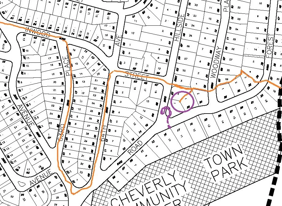
Stray line.
Both the Ward 4 and Ward 6 boundary descriptions in the town charter include a stray line — a property line that is squarely within Ward 4 was mistakenly listed as a boundary line.
From the Ward 4 boundary description:
Fourth Ward: All that area south and east of a line running from a point at the intersection of the eastern boundary and the rear lot line of 6435 Forest Road (Lot 19) along the northeast side lot line of the same lot, across Forest Road to the eastern side lot line of 6432 Forest Road, along the eastern side lot line of the same lot and running in a northwest direction along the rear lot lines of 6432, 6430, 6428, 6424, and 6422 Forest Road and continuing along the northern side lot line of 2803 Hillside Avenue, running along Inwood Street west to 64th Avenue and then southwest along 64th Avenue…
[Emphasis added]
And an excerpt from the Ward 6 boundary description:
…running to Landover Road and then east to the boundary of the town and continuing along the eastern boundary of the town south until a point at the intersection of the eastern boundary and the rear lot line of 6435 Forest Road (Lot 19) along to the northeast side lot line of the same lot, across Forest Road to the eastern side lot line of 6432 Forest Road, along the eastern side lot line of the same lot and running in a northwest direction along the rear lot lines of 6432, 6430, 6428, 6424, and 6422 Forest Road and continuing along the north side lot line of 2803 Hillside Avenue, running along Inwood Street to 64th Avenue, then south on 64th Avenue to Forest Road…
[Emphasis added]
The issue here is that 6422 Forest Road is south of 2803 Hillside Avenue, so the “rear lot line” of 6422 Forest Road does not add very much to the boundary, other than an odd line off by itself. Here is a map zoomed in on the lot boundary for 2803 Hillside:

Shaded blue trapezoid illustrates lot boundaries for 2803 Hillside Avenue
And here is the lot for 6422 Forest Road:

Shaded blue trapezoid illustrating lot boundaries for 6422 Forest Road.
The slanty sides of the two trapezoids are where the two properties align. 6422 Forest Road is just south of 2803 Hillside Avenue, not east of it. That means the “rear lot line” of 6422 Forest Road cannot really mark a boundary between Ward 6 and Ward 4, since the north edge of 2803 Hillside Avenue forms the border. When you try to draw the boundary according to the town charter (which I did in orange below), you get this stray line (circled in purple):
“Avenue,” not “Place.”
One part of the Ward 6 boundary mistakenly referred to 63rd Place when it should have referred to 63rd Avenue. This is a portion of Ward 6 that is adjacent to Ward 3. The Ward 3 boundary description lists the correct street name.
An excerpt from the Ward 6 boundary description:
…then south on 64th Avenue to Forest Road, then southwest on Forest Road to 63rd Avenue to its intersection with 63rd Place, then north on 63rd Place to Inwood and north west along Inwood and then along 63rd Place until it changes its name to 62nd Place, then along 62nd Place until the boundary of the town in the northwest corner of Gladys Noon Spellman Elementary School and from there in a northeasterly direction along the boundary of the town to the intersection of Oak Street and Kilmer Street.
[Emphasis added]
The Ward 3 boundary description:
Third Ward: All the area contained in a line beginning at the northern boundary and Cheverly Avenue and running south on Cheverly Avenue to where Forest Road crosses Cheverly Avenue, then east on Forest Road to 63rd Avenue to its intersection with 63rd Place, then north on 63rd Place to Inwood Street, then northwest on Inwood Street to 63rd Avenue, then north-northwest on 63rd Avenue until it changes its name to 62nd Place, then along 62nd Place until the northern boundary, and then west along the northern boundary to Cheverly Avenue.
[Emphasis added]
It really is 63rd Avenue that changes its name to 62nd Place, as the Google map below illustrates:

Map of northeastern part of Cheverly. Labeled near the center of the map is St. Ambrose Catholic Church, on 63rd Avenue. Following 63rd Avenue northward, it becomes 62nd Place, which then intersects with Route 202 (also called Landover Road, top of map).
“East,” not “West.”
The description of the Ward 5 boundary turns west when it should have turned east. The boundary description:
Fifth Ward: All that area east and north of a line beginning at the northern boundary of the town at Landover Road and 63rd Place and running south on 63rd Place for approximately one half block to the boundary of the Town and then west along the boundary of the town that runs along the south side of the Cheverly Station apartments, then north on Kilmer Street for a short distance until a point between 6507 and 6513 Landover Road in the Cheverly Station Apartments and then east along the south wall of 6507, 6509 and 6511 Landover Road (Cheverly Station Apartments), then north to the southeast corner of 6505 Landover Road and north along the west wall of 6505 Landover Road, then east along the northern wall of 6505 Landover Road, then turning north at the northeast corner of 6505 Landover Road and running to Landover Road and then east to the boundary of the town.
[Emphasis added]
The Cheverly Station apartments are east of 63rd Place, not west. The northbound part of Kilmer Street is east of 63rd Place also.

Map of northern part of Cheverly, with 63rd Place marked in red. “THESE are the apartments” marked east of 63rd Place, with the northern part of Kilmer Street circled, even further to the east.